Devil's Backbone State Natural Area is located on the Natchez Trace Parkway at milepost 394.

Hiking Trail 3 mile-long loop trail
Devil's Backbone State Natural Area

Scroll down the page to view more pictures!

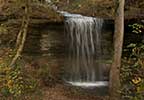
The Devil's Backbone State Natural Area, located adjacent to the Natchez Trace Parkway at milepost 394, offers the opportunity for a quiet hike in a natural environment little affected by modern human action.

The trail takes hikers from the parking area just off the Natchez Trace Parkway out along the ridges of Tennessee's Highland Rim, down along a creek, and back again. The trail is a moderately strenuous loop with 200 feet of elevation change that is about 3 miles long.

Devil's Backbone State Natural Area Photo Gallery
More info about Devil's Backbone State Natural Area and similar sites.
  • Click for a Location Map
  • Latitude: 35.6054982
    Longitude: -87.406196
    Elevation (approximate): 1010 feet
    Milepost: 394
Next stop to the South Next stop to the North Natchez Trace Hiking Trails

Natchez Trace Travel: Home - Facebook - Instagram - Merchandise

Back to Top