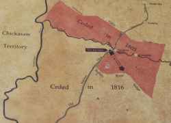
Before 1805 the Chickasaw Indians owned all the land in this vicinity. Only the Natchez Trace, part of which remains here, made inroads into tribal territory.
When the Indians ceded the land to the United States in the early 1800s the Natchez Trace became a boundary. The land behind you became government property under the 1805 treaty. In 1816 the tribe ceded a much larger tract including the land in front of you.
Eventually the Chickasaw left their homeland. In 1837 the government removed them to the Indian territory in Oklahoma over the tragic Trail of Tears.
Despite the dissolution of their lands, the Chickasaw evolved a unique culture based on the American model. As hunting ranges shrank and they became farmers the Chickasaw established their own schools, courts and legislature.
During the Civil War the tribe joined the Confederacy. Tishomingo was the last of the Chickasaw War Chiefs. Winchester Colbert was a mixed blood governor of the Chickasaw nation.


