Towns, Historic Villages and Cities near the Natchez Trace Parkway
Towns, Historic Villages and Cities located along or near the Natchez Trace Parkway.
Click on any of the locations for information and pictures about the town.
Tennessee - Alabama - Mississippi - Location Map
Tennessee


- Nashville - Exit the Trace at the northern terminus (milepost 442) onto either Tennessee Highway 100 and travel east into Nashville. Or, exit the Trace onto McCrory Lane and travel north about four miles to Interstate 40 East to Nashville.
- Franklin - Exit the Trace at milepost 438 onto Tennessee Highway 96 and travel east eight miles to Franklin.
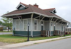
- Leipers Fork Historic Village - Exit the Trace at milepost 428 onto Tennessee Highway 46 and travel east one mile to Leipers Fork.
- Columbia - If you are traveling south, exit the Trace at milepost 416 onto Tennessee Highway 7 and travel east to Columbia (17 miles). Or, if you are traveling north, exit the Trace at milepost 391 onto US Highway 412 and travel east to Columbia (24 miles).
- Hohenwald - If you are traveling south, exit the Trace at milepost 391 onto US Highway 412 and travel about 8 miles west to Hohenwald. Or, if you are traveling north, exit the Trace at milepost 386 onto Tennessee Highway 20 and travel about six miles west to Hohenwald.
- Linden - If you are traveling south, exit the Trace at milepost 391 onto US Highway 412 and travel about 27 miles west through Hohenwald to Linden. Or, if you are traveling north, exit the Trace at milepost 386 onto Tennessee Highway 20 and travel west to Hohenwald and then west on US412 to Linden.
- Hampshire - Exit the Trace at milepost 391 onto US Highway 412 and travel east 9 miles.
- Lawrenceburg - Exit the Trace at milepost 370 onto US Highway 64 and travel east 20 miles to Lawrenceburg.
- Clifton - Exit the Trace near milepost 370 onto US 64 West and travel thru Waynesboro. Continue on US 64 another 12 miles past Waynesboro to Tennessee Highway 114 North (Billy Nance Highway). Travel north 6 miles to Clifton.
- Collinwood - Exit the Trace at milepost 355 at the Collinwood Exit and travel west 150 yards to Collinwood.
Alabama


- Florence - Exit the parkway near milepost 336 onto Alabama Highway 20 OR near milepost 333 onto Lauderdale County Road 14 and travel east 15 miles to Florence.
- Tuscumbia - Exit the parkway at milepost 320 onto US Highway 72 and travel east 19 miles.
Mississippi


- Corinth - If traveling south, exit the Trace in Alabama at milepost 320 onto US Highway 72 and travel west 35 miles. If traveling north, access US 45 north of Tupelo and travel north 45 miles.
- Tishomingo - Exit the Trace at milepost 303 onto Mississippi Highway 25 and travel north 2 miles.
- Belmont - If traveling south, exit the Trace at milepost 303 onto Mississippi Highway 25 and travel south 7 miles. Or, if traveling north, exit the Trace at milepost 297 onto Mississippi Highway 4 and travel east to Mississippi Highway 25 and then south on highway 25.
- Baldwyn - Exit the Trace at milepost 282 onto Mississippi Highway 370/371 and travel west 11 miles.
- Tupelo - The Trace travels through the city of Tupelo. There are five exits from the Trace into Tupelo.
- Pontotoc - If traveling north on the parkway, exit at milepost 246 onto Mississippi Highway 41 and travel north 15 miles to Pontotoc. If traveling south on the parkway, exit at milepost 257 onto Mississippi Highway 76 (Pontotoc Parkway) and travel west 20 miles to Pontotoc.
- Houston - Exit the Trace at milepost 230 onto Mississippi Highway 8 and travel west 5 miles.
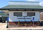
- French Camp Historic Village - Exit the Trace at milepost 180.7 onto Mississippi Highway 413 and travel east 100 yards.
- Kosciusko - Exit the Trace at milepost 160 at either the Kosciusko Information Center or Mississippi Highway 35 and travel west 1 mile.
- Canton - Exit the Trace at milepost 115 onto Mississippi Highway 43 and travel north 8 miles.
- Jackson - The Trace travels around the west side of Jackson. There are several exits from milepost 87 to milepost 103 including exits from Interstates 20 and 55.
- Clinton - The Trace travels thru Clinton. Exit the Trace at milepost 89 onto Pinehaven Drive.
- Raymond - Exit the Trace at milepost 79 onto Mississippi Highway 467 and travel east 2 miles.
- Vicksburg - Vicksburg is located 20-30 miles west of the Natchez Trace Parkway. I-20, Mississippi Highway 27 and U.S. 61 connect travelers from the Trace to Vicksburg.
- Port Gibson - Exit the Trace at milepost 41 onto Mississippi Highway 18 and travel west. At the intersection with U.S. Highway 61 turn left (south) and travel into Port Gibson.
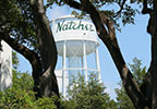
- Natchez - Exit the Trace at milepost 0 (southern terminus) onto Liberty Road. Follow the signs to Downtown Natchez.
The map link below shows the location of Natchez Trace access / exit roads and nearby towns, villages and cities.. Optionally, you can click on the map's Filter link to add locations for Natchez Trace Sites, Places to Stay, Restaurants, Markets and Merchants to the map.
Click here to view a map showing Towns, Villages and Cities located near the Natchez Trace Parkway.