Witch Dance is located on the Natchez Trace Parkway at milepost 233.2.

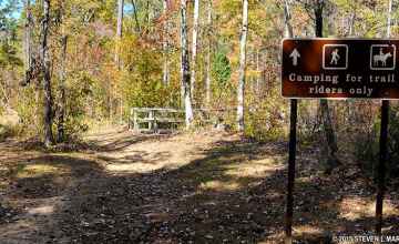
Hiking Trail trailhead of the Witch Dance Horse Trail in the Tombigbee National Forest (18 mile multi-loop horseback and hiking trail)
Picnic Area 17 picnic tables, 5 grills
Restrooms
Witch Dance - Natchez Trace Parkway
Witch Dance Mississippi

Photo Credit: Steven Markos - National Park Planner
Scroll down the page to view more Witch Dance pictures!

The Witch Dance site is a trailhead for the Witch Dance Horse Trail (part of the Tombigbee National Forest). The horseback and hiking trail is 18 miles long with multiple loops. The trail, one of the most popular horse trails in Mississippi, winds through varied topography and changing forest settings.

Restrooms, hitching posts, and parking are provided.

The very name conjures visions of eerie midnights, swirling black capes and brooms stacked against a nearby tree. The old folks say the witches gathered here to dance and wherever their feet touched the ground the grass withered and died never to grow again. Impossible? Maybe so, but look around. Look for a hidden spot where no grass grows.
Witch Dance Photo Gallery
More info about Witch Dance and similar sites.
  • Click for a Location Map
  • Latitude: 33.9116166
    Longitude: -88.939
    Elevation (approximate): 410 feet
    Milepost: 233.2
Next stop to the South Next stop to the North Restrooms available Picnic tables available Natchez Trace Hiking Trails

Natchez Trace Travel: Home - Facebook - Instagram - Merchandise

Back to Top