Vicksburg - Port Gibson Mississippi Natchez Trace
This section of the Natchez Trace is located near Vicksburg and Port Gibson, Mississippi.
The section spans the area between the Mississippi Highway 27 intersection (milepost 66) and the Mississippi Highway 552 intersection (milepost 30).
Listed below:


milepost 61.0 - History/Nature Exhibit, Indian History

milepost 54.8 - Restroom, Picnic Area, Hiking Trail, History/Nature Exhibit, Old Trace, Campground, Top 30 Favorite Site

milepost 52.4 - Hiking Trail, Waterfall, Picnic Area
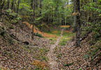
milepost 45.7 - Old Trace, Indian History, Hiking Trail
milepost 45.7 - Indian History

milepost 41.5 - Old Trace, Top 30 Favorite Site
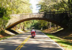
Scenery you can see from the road while driving, biking or riding the Vicksburg - Port Gibson section of the parkway.

Vicksburg National Military Park
Located west of the Natchez Trace Parkway in Vicksburg, Mississippi. I-20, Mississippi Highway 27 and U.S. 61 connect travelers from the Trace to Vicksburg.
Exit the Trace at milepost 41 onto Mississippi Highway 18. Turn left (south) on US 61 and drive into Port Gibson. From the courthouse area in Port Gibson take Anthony Street out of town heading northwest. Anthony Street becomes Oil Mill Road. Oil Mill Road dead-ends into Grand Gulf Road. Turn left on Grand Gulf Road and follow the road to the park.

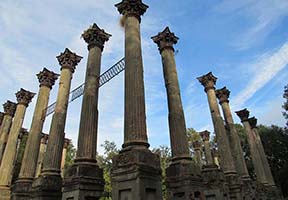
Top 30 Favorite Site - Exit the Trace at milepost 30 onto Mississippi Highway 552 and travel west. Follow the signs to Windsor Ruins.

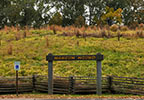
A.K. Shaifer House / Battle of Port Gibson
Located between Port Gibson and Windsor Ruins.


Located on Church Street.


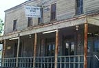
The Old Country Store Restaurant - Lorman, MS
Open every day for lunch (until 4 p.m.).
in Vicksburg via I-20, MS Hwy 27, Fisher Ferry Road or US 61 exit:
- Rusty's Riverfront Grill - Open Tuesday thru Saturday for lunch and dinner.
- Walnut Hills Restaurant - Open Monday and Wednesday thru Saturday for lunch and dinner, Sunday for lunch, closed Tuesday.
- 10 South Rooftop Bar and Grill - Open Tuesday thru Sunday for lunch and dinner,
Fisher Ferry Road exit (milepost 59):
- Crossroads Country Store - Open every day for lunch thru dinner.
MS Hwy 552 exit (milepost 30):
- The Old Country Store Restaurant - Open every day for lunch.

Vicksburg is located 20-30 miles west of the Natchez Trace Parkway. I-20, Mississippi Highway 27 and U.S. 61 connect travelers from the Trace to Vicksburg.

Exit the Trace at milepost 41 onto Mississippi Highway 18 and travel west. At the intersection with U.S. Highway 61 turn left (south) and travel into Port Gibson.
- Mississippi Highway 27 - milepost 66 - Vicksburg | Utica
- Fisher Ferry Road - milepost 59 - Vicksburg | Utica - Food nearby
- Mississippi Highway 18 - milepost 41 - Port Gibson - Food & Gas nearby
- US Highway 61 - milepost 37 - Port Gibson - Food & Gas nearby
- Mississippi Highway 552 - milepost 30 - Alcorn | Lorman - Food nearby
- Whispers in the Cedars - Port Gibson - late March / early April
- Vicksburg Riverfest - Vicksburg - early April
- Car, Truck and Motorcycle Show - Port Gibson - June
- Vicksburg Independence Day Fireworks Celebration - Vicksburg - July
- Old Man River Quiltfest - Vicksburg - August
- Port Gibson Christmas Parade - Port Gibson - December