
https://www.natcheztracetravel.com/natchez-trace-mississippi/loop-routes/573-windsor-ruins.html#sigProIdd87ee59e0d
People from all over the world travel to see Windsor Ruins. Built just before the Civil War, Windsor was one of the largest plantations in the area. Unfortunately, in 1890 a house guest left a lighted cigar on the upper balcony and Windsor burned to the ground. Everything was destroyed except 23 of the columns, balustrades and iron stairs.
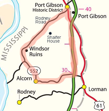
The Windsor Ruins Loop is 32 miles long - 20 miles along Mississippi Highway 552/Rodney Road, 7 miles along the Natchez Trace Parkway from milepost 30 to 37 and 5 miles through the town of Port Gibson and back to the Trace.
Driving/biking from the south end of the loop you will see:
Canemount Plantation:
About two miles north of Alcorn sits Canemount Plantation on the east side of the road. Canemount was established in the early 19th century with several buildings dating back to 1826 still standing. The centerpiece is the Italianate Revival built in 1855. Today, Canemount is a bed and breakfast.
Bethel Church:
A mile north of Canemount Plantation and two and a half miles south of Windsor Ruins sits historic Bethel Church.
The original congregation of the Bethel Presbyterian Church organized in 1826 under the direction of Dr. Jeremiah Chamberlain. The building, that still stands today, was built in the mid 1840s. During Grant’s campaign to take Vicksburg, he landed his troops east of the Mississippi River just a few miles from here at Bruinsburg. His troops passed Bethel Church on April 30th, 1863 moving to Port Gibson on the Rodney Road.
Windsor Ruins:
Legend says that from a roof observatory, Mark Twain watched the Mississippi River in the distance. Leading up to the Battle of Port Gibson in the spring of 1863, confederate troops used the roof observatory as a lookout as Grant's army crossed the Mississippi River. After the battle the mansion was used as a Union hospital and observation post, thus sparing it from being burned by Union troops. For more pictures, information and a map please click here.
A.K. Shaifer House:
The first shot of The Battle of Port Gibson was fired at the Shaifer House on May 1, 1863. Grant's army, after marching past Bethel Church and Windsor Ruins first encountered confederate troops on the way to Port Gibson at the Shaifer House. For directions to the Shaifer House, more pictures, information and a map please click here.
Port Gibson, Mississippi:
Chartered as a town on March 12, 1803, Port Gibson is Mississippi's third oldest settlement, being occupied in 1729. Most of Port Gibson's historic buildings survived the Civil War because Grant believed the city "too beautiful to burn". Historic Church Street through the middle of town is lined with antebellum homes and church buildings. For more pictures, information and a map please click here.
Biking
Many people bicycle the Windsor Ruins Loop. Mississippi Highway 552 from the Trace at milepost 30 for five miles to Alcorn is a four lane highway with moderate traffic. Fortunately, there is a very wide shoulder/bike lane on both sides of the highway. Here the highway veers to the right (north). If you go left you will find yourself at the entrance to Alcorn State University. North of Alcorn, Highway 552 narrows down to a country two-lane road with light traffic. After another mile or so the road is known as Rodney Road as it follows a route that has been traveled for over 200 years.
There are two places to park your vehicle. At the south end of the loop there is a parking area on the Trace near milepost 29 just south of Highway 552.
At the north end of the loop you can leave your vehicle in Port Gibson (there is public parking near the Clairborne County Courthouse). To avoid bicycling on US 61 there is a back-roads route from the Trace at milepost 39.2 into Port Gibson:
- Exit the Natchez Trace Parkway at milepost 39.2 at the Port Gibson District Office (Ranger Station) where the parkway goes over MS Hwy 547 (McComb Avenue). On the north side of the overpass walk your bikes off the parkway to the east and down to hwy 547.
- Then bike west back under the parkway and then about 3000 feet on McComb Avenue. Turn right onto Bridewell Lane.
- Bike almost one mile on Bridewell Lane and then turn left onto Chinquepin Street.
- After about 7 blocks you will be at the corner of Chinquepin Street and Church Street.
Directions
From the south, exit the Trace at milepost 30 onto Mississippi Highway 552 going west and follow the signs to Windsor Ruins.
From the north exit the Trace at either milepost 41 (Mississippi Highway 18) or milepost 37 (US 61). Follow US 61 into town where the road becomes Church Street. Go west on Carroll Street. Rodney Road starts where Carroll and Flower Streets intersect.
Services
There are markets and restaurants in Port Gibson and The Old Country Store Restaurant is located 2 miles east of the southern end of the loop in Lorman, MS.
Lodging
Canemount Plantation Inn Bed and Breakfast
Isabella Bed and Breakfast
Collina Plantation Inn Bed and Breakfast
Ride with GPS maps, cue sheets and points of interest.
Biking Clockwise:
Biking Counter Clockwise: