Natchez Trace Bicycle Itinerary - North to South, 4 Days
On this Natchez Trace Parkway Bicycle Itinerary cyclists will bike North to South for 4 days from the Northern Terminus (milepost 442 - Nashville, TN) to the Southern Terminus (milepost 0 - Natchez, MS).
Ride Stats for entire 4-day itinerary.
- Does not include miles to/from Parkway for lodging.
- Total Miles on Parkway and Multi-Use Path: 446
Average miles per day: 111.5 - Total Elevation Gain:
15,751 feet (avg. 35.3 feet/mile) - Total Elevation Loss:
16,281 feet (avg. 36.5 feet/mile)
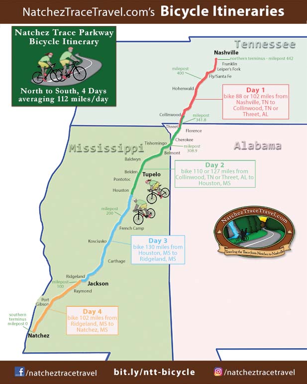
Ride Stats for Day 1
milepost 442 to milepost 355:
- Miles on Parkway: 87.6
- Elevation Gain:
5,392 feet (avg. 61.6 feet/mile)
Maximum Grade: 8.9% - Elevation Loss:
5,002 feet (avg. 57.1 feet/mile)
Minimum Grade: -8.1%
milepost 442 to milepost 341:
- Miles on Parkway: 101.9
- Elevation Gain:
5,549 feet (avg. 54.5 feet/mile)
Maximum Grade: 8.9% - Elevation Loss:
5,552 feet (avg. 54.5 feet/mile)
Minimum Grade: -8.0%
- Route Overview Map for Day 1 (Route along the Parkway and Routes to/from Lodging at start and end of the Day)
- Restrooms, Top 30 Favorite Sites, and Exits with Services Nearby Along the Way from Milepost 442 to Milepost 341
- Lodging, Featured Points of Interest and Food at the end of the Day near the Parkway at Milepost 355 and Milepost 341
August 16, 2023:
A 17.7-mile-long section of the Natchez Trace Parkway south of Tupelo, MS closed for road rehabilitation and paving between milepost 256.9 (intersection with MS 6/US 278) and milepost 239.2 (intersection with MS Hwy 32).
Update on December 14, 2023:
The closed section of Natchez Trace Parkway, from milepost 256.9 to milepost 239.2, has reopened to traffic.
- Travelers should expect single-lane closures into the Summer of 2024.
Work continues to add an additional layer of asphalt, add permanent striping, and grade the shoulder. - If you are biking WITH a support vehicle, you might consider driving these 17.7 miles (especially if there is a long stretch of single-lane traffic).
Hopefully, only 2 miles or less of the 17.7 miles will be single-lane traffic at a time. - When cycling always wear brightly colored clothing and have both front and rear flashing lights on your bicycle.
Ride Stats for Day 2
milepost 355 to milepost 230:
- Miles on Parkway: 126.6
- Elevation Gain:
4,083 feet (avg. 32.3 feet/mile)
Maximum Grade: 5.9% - Elevation Loss:
4,815 feet (avg. 38.0 feet/mile)
Minimum Grade: -6.5%
milepost 338 to milepost 230:
- Miles on Parkway: 109.5
- Elevation Gain:
3,846 feet (avg. 35.1 feet/mile)
Maximum Grade: 5.9% - Elevation Loss:
4,167 feet (avg. 38.1 feet/mile)
Minimum Grade: -6.5%
- Route Overview Map for Day 2 (Route along the Parkway and Routes to/from Lodging at start and end of the Day)
- Restrooms, Top 30 Favorite Sites, and Exits with Services Nearby Along the Way from Milepost 355 to Milepost 230
- Lodging, Featured Points of Interest and Food at the end of the Day near the Parkway at Milepost 230
Ride Stats for Day 3
- Miles on Parkway and Multi-Use Path: 130
- Elevation Gain:
3,119 feet (avg. 24.0 feet/mile)
Maximum Grade: 5.1% - Elevation Loss:
3,105 feet (avg. 23.9 feet/mile)
Minimum Grade: -5.0%
- Route Overview Map for Day 3 (Route along the Parkway and Routes to/from Lodging at start and end of the Day)
- Restrooms, Top 30 Favorite Sites, and Exits with Services Nearby Along the Way from Milepost 230 to Milepost 100
- Lodging, Featured Points of Interest and Food at the end of the Day near the Parkway at Milepost 100

Ride Stats for Day 4
- Miles on Parkway: 102
- Elevation Gain:
3,751 feet (avg. 36.8 feet/mile)
Maximum Grade: 5.4% - Elevation Loss:
3,961 feet (avg. 38.8 feet/mile)
Minimum Grade: -3.4%
- Route Overview Map for Day 4 (Route along the Parkway and Routes to/from Lodging at start and end of the Day)
- Restrooms, Top 30 Favorite Sites, and Exits with Services Nearby Along the Way from Milepost 101 to Milepost 0
- Lodging, Featured Points of Interest and Food at the end of the Day near the Parkway at Milepost 0
Do you appreciate this information and advice?
Natchez Trace Travel Planner
Parkway Map, Top 30 Favorite Sites and Nearby Lodging Map, Lodging Flyer
I/We "Bicycled the Natchez Trace" Merchandise