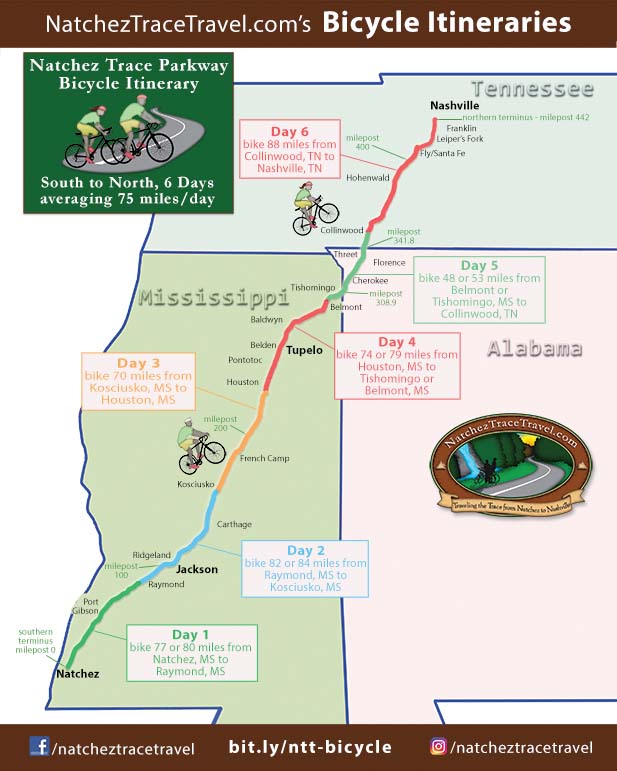
Natchez Trace Bicycle Itinerary - South to North, 6 Days
On this Natchez Trace Parkway Bicycle Itinerary cyclists will bike South to North for 6 days from the Southern Terminus (milepost 0 - Natchez, MS) to the Northern Terminus (milepost 442 - Nashville, TN)
Ride Stats for entire 6-day itinerary.
- Does not include miles to/from Parkway for lodging.
- Total Miles on Parkway and Multi-Use Path: 446
Average miles per day: 74.3 - Total Elevation Gain:
16,287 feet (avg. 36.5 feet/mile) - Total Elevation Loss:
15,755 feet (avg. 35.3 feet/mile)
Ride Stats for Day 1
milepost 0 to milepost 76.3:
- Miles on Parkway: 76.8
- Elevation Gain:
3,091 feet (avg. 40.2 feet/mile)
Maximum Grade: 3.6% - Elevation Loss:
2,982 feet (avg. 38.8 feet/mile)
Minimum Grade: -5.2%
milepost 0 to milepost 79:
- Miles on Parkway: 79.6
- Elevation Gain:
3,198 feet (avg. 40.2 feet/mile)
Maximum Grade: 3.7% - Elevation Loss:
3,051 feet (avg. 38.3 feet/mile)
Minimum Grade: -5.3%
- Route Overview Map for Day 1 (Route along the Parkway and Routes to/from Lodging at start and end of the Day)
- Restrooms, Top 30 Favorite Sites, and Exits with Services Nearby Along the Way from Milepost 0 to Milepost 79
- Lodging, Featured Points of Interest and Food at the end of the Day near the Parkway at Milepost 76/79
Ride Stats for Day 2
milepost 76.3 to milepost 160:
- Miles on Parkway: 84.2
- Elevation Gain:
1,909 feet (avg. 22.7 feet/mile)
Maximum Grade: 2.3% - Elevation Loss:
1,744 feet (avg. 20.7 feet/mile)
Minimum Grade: -2.9%
milepost 79 to milepost 160:
- Miles on Parkway: 81.6
- Elevation Gain:
1,814 feet (avg. 22.2 feet/mile)
Maximum Grade: 2.3% - Elevation Loss:
1,692 feet (avg. 20.7 feet/mile)
Minimum Grade: -2.9%
- Route Overview Map for Day 2 (Route along the Parkway and Routes to/from Lodging at start and end of the Day)
- Restrooms, Top 30 Favorite Sites, and Exits with Services Nearby Along the Way from Milepost 76 to Milepost 160
- Lodging, Featured Points of Interest and Food at the end of the Day near the Parkway at Milepost 160

Ride Stats for Day 3
- Miles on Parkway: 69.9
- Elevation Gain:
2,005 feet (avg. 28.7 feet/mile)
Maximum Grade: 4.7% - Elevation Loss:
2,085 feet (avg. 29.8 feet/mile)
Minimum Grade: -4.3%
- Route Overview Map for Day 3 (Route along the Parkway and Routes to/from Lodging at start and end of the Day)
- Restrooms, Top 30 Favorite Sites, and Exits with Services Nearby Along the Way from Milepost 160 to Milepost 230
- Lodging, Featured Points of Interest and Food at the end of the Day near the Parkway at Milepost 230
August 16, 2023:
A 17.7-mile-long section of the Natchez Trace Parkway south of Tupelo, MS closed for road rehabilitation and paving between milepost 239.2 (intersection with MS Hwy 32) and milepost 256.9 (intersection with MS 6/US 278).
Update on December 14, 2023:
The closed section of Natchez Trace Parkway, from milepost 239.2 to milepost 256.9, has reopened to traffic.
- Travelers should expect single-lane closures into the Summer of 2024.
Work continues to add an additional layer of asphalt, add permanent striping, and grade the shoulder. - If you are biking WITH a support vehicle, you might consider driving these 17.7 miles (especially if there is a long stretch of single-lane traffic).
Hopefully, only 2 miles or less of the 17.7 miles will be single-lane traffic at a time. - When cycling always wear brightly colored clothing and have both front and rear flashing lights on your bicycle.
Ride Stats for Day 4
milepost 230 to milepost 293:
- Miles on Parkway: 64.1
- Elevation Gain:
2,171 feet (avg. 33.9 feet/mile)
Maximum Grade: 3.5% - Elevation Loss:
2,133 feet (avg. 33.3 feet/mile)
Minimum Grade: -4.5%
milepost 230 to milepost 303:
- Miles on Parkway: 73.5
- Elevation Gain:
2,675 feet (avg. 36.4 feet/mile)
Maximum Grade: 4.9% - Elevation Loss:
2,406 feet (avg. 32.7 feet/mile)
Minimum Grade: -5.0%
milepost 230 to milepost 307:
- Miles on Parkway: 78.5
- Elevation Gain:
2,781 feet (avg. 36.4 feet/mile)
Maximum Grade: 6.5% - Elevation Loss:
2,644 feet (avg. 32.7 feet/mile)
Minimum Grade: -5.0%
- Route Overview Map for Day 4 (Route along the Parkway and Routes to/from Lodging at start and end of the Day)
- Restrooms, Top 30 Favorite Sites, and Exits with Services Nearby Along the Way from Milepost 230 to Milepost 307
- Lodging, Featured Points of Interest and Food at the end of the Day near the Parkway at Mileposts 293, 303 or 307
Ride Stats for Day 5
milepost 303 to milepost 355:
- Miles on Parkway: 52.7
- Elevation Gain:
2,215 feet (avg. 42.0 feet/mile)
Maximum Grade: 6.3% - Elevation Loss:
1,766 feet (avg. 33.5 feet/mile)
Minimum Grade: -5.6%
milepost 307 to milepost 355:
- Miles on Parkway: 48.1
- Elevation Gain:
2,038 feet (avg. 42.4 feet/mile)
Maximum Grade: 6.3% - Elevation Loss:
1,450 feet (avg. 30.1 feet/mile)
Minimum Grade: -5.7%
- Route Overview Map for Day 5 (Route along the Parkway and Routes to/from Lodging at start and end of the Day)
- Restrooms, Top 30 Favorite Sites, and Exits with Services Nearby Along the Way from Milepost 303 to Milepost 355
- Lodging, Featured Points of Interest and Food at the end of the Day near the Parkway at Milepost 355
Ride Stats for Day 6
- Miles on Parkway: 87.8
- Elevation Gain:
5,011 feet (avg. 57.1 feet/mile)
Maximum Grade: 8.4% - Elevation Loss:
5,401 feet (avg. 61.5 feet/mile)
Minimum Grade: -9.8%
- Route Overview Map for Day 6 (Route along the Parkway and Routes to/from Lodging at start and end of the Day)
- Restrooms, Top 30 Favorite Sites, and Exits with Services Nearby Along the Way from Milepost 355 to Milepost 442
- Lodging, Featured Points of Interest and Food at the end of the Day near the Parkway at Milepost 442
Do you appreciate this information and advice?
Natchez Trace Travel Planner
Parkway Map, Top 30 Favorite Sites and Nearby Lodging Map, Lodging Flyer
I/We "Bicycled the Natchez Trace" Merchandise