Natchez Trace Parkway North to South Bicycle Day Routes
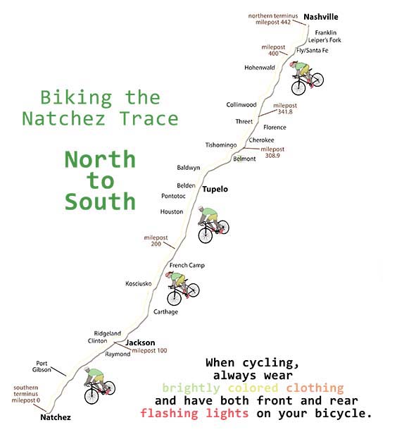
One Day, North to South Natchez Trace Bicycle Routes starting in:
- Nashville, TN (Northern Terminus at milepost 442)
- Fly / Santa Fe, TN (milepost 416)
- Hohenwald, TN (milepost 385.9)
- Collinwood, TN (milepost 355)
- Threet, AL (milepost 338)
- Tishomingo, MS (milepost 307) or Belmont, MS (milepost 303)
- Tupelo, MS area (milepost 276 or 262 or 256)
- Houston, MS (milepost 230)
- French Camp, MS (milepost 181)
- Kosciusko, MS (milepost 160)
- Carthage, MS area (milepost 136.4)
- Ridgeland, MS (milepost 100)
- Raymond, MS (milepost 79 or 76)
- Port Gibson, MS (milepost 41-39)
One Day, North to South Routes starting in Nashville, TN (Northern Terminus at milepost 442)
Ride Stats
- Miles on Parkway: 26.7
- Elevation Gain:
1,964 feet (avg. 73.6 feet/mile)
Maximum Grade: 8.6% - Elevation Loss:
1,802 feet (avg. 67.5 feet/mile)
Minimum Grade: -6.9%
Click Here to View Route Details:
- Route Overview Map (Route along the Parkway and Routes to/from Lodging at start and end of the Day)
- Restrooms, Top 30 Favorite Sites, and Exits with Services Nearby Along the Way from Milepost 442 to Milepost 416
- Lodging, Featured Points of Interest and Food at the end of the Day near the Parkway at Milepost 416
Ride Stats
- Miles on Parkway: 56.6
- Elevation Gain:
4,044 feet (avg. 71.4 feet/mile)
Maximum Grade: 9.2% - Elevation Loss:
3,800 feet (avg. 67.1 feet/mile)
Minimum Grade: -8.3%
Click Here to View Route Details:
- Route Overview Map (Route along the Parkway and Routes to/from Lodging at start and end of the Day)
- Restrooms, Top 30 Favorite Sites, and Exits with Services Nearby Along the Way from Milepost 442 to Milepost 385.9
- Lodging, Featured Points of Interest and Food at the end of the Day near the Parkway at Milepost 385.9
Ride Stats
- Miles on Parkway: 87.9
- Elevation Gain:
5,397 feet (avg. 61.4 feet/mile)
Maximum Grade: 8.9% - Elevation Loss:
5,026 feet (avg. 57.2 feet/mile)
Minimum Grade: -8.1%
Click Here to View Route Details:
- Route Overview Map (Route along the Parkway and Routes to/from Lodging at start and end of the Day)
- Restrooms, Top 30 Favorite Sites, and Exits with Services Nearby Along the Way from Milepost 442 to Milepost 355
- Lodging, Featured Points of Interest and Food at the end of the Day near the Parkway at Milepost 355
Ride Stats
milepost 442 to milepost 355:
- Miles on Parkway: 87.6
- Elevation Gain:
5,392 feet (avg. 61.6 feet/mile)
Maximum Grade: 8.9% - Elevation Loss:
5,002 feet (avg. 57.1 feet/mile)
Minimum Grade: -8.1%
milepost 442 to milepost 341:
- Miles on Parkway: 101.9
- Elevation Gain:
5,549 feet (avg. 54.5 feet/mile)
Maximum Grade: 8.9% - Elevation Loss:
5,552 feet (avg. 54.5 feet/mile)
Minimum Grade: -8.0%
Click Here to View Route Details:
- Route Overview Map (Route along the Parkway and Routes to/from Lodging at start and end of the Day)
- Restrooms, Top 30 Favorite Sites, and Exits with Services Nearby Along the Way from Milepost 442 to Milepost 341
- Lodging, Featured Points of Interest and Food at the end of the Day near the Parkway at Milepost 355 and Milepost 341

One Day, North to South Routes starting in Fly / Santa Fe, TN (milepost 416)
Ride Stats
- Miles on Parkway: 29.9
- Elevation Gain:
2,091 feet (avg. 69.9 feet/mile)
Maximum Grade: 8.8% - Elevation Loss:
1,988 feet (avg. 66.5 feet/mile)
Minimum Grade: -8.0%
Click Here to View Route Details:
- Route Overview Map (Route along the Parkway and Routes to/from Lodging at start and end of the Day)
- Restrooms, Top 30 Favorite Sites, and Exits with Services Nearby Along the Way from Milepost 416 to Milepost 385.9
- Lodging, Featured Points of Interest and Food at the end of the Day near the Parkway at Milepost 385.9
Ride Stats
- Miles on Parkway: 60.9
- Elevation Gain:
3,434 feet (avg. 56.4 feet/mile)
Maximum Grade: 8.7% - Elevation Loss:
3,192 feet (avg. 52.4 feet/mile)
Minimum Grade: -7.8%
Click Here to View Route Details:
- Route Overview Map (Route along the Parkway and Routes to/from Lodging at start and end of the Day)
- Restrooms, Top 30 Favorite Sites, and Exits with Services Nearby Along the Way from Milepost 416 to Milepost 355
- Lodging, Featured Points of Interest and Food at the end of the Day near the Parkway at Milepost 355
One Day, North to South Routes starting in Hohenwald, TN (milepost 385.9)
Ride Stats
- Miles on Parkway: 31
- Elevation Gain:
1,424 feet (avg. 45.9 feet/mile)
Maximum Grade: 4.7% - Elevation Loss:
1,290 feet (avg. 41.6 feet/mile)
Minimum Grade: -3.9%
Click Here to View Route Details:
- Route Overview Map (Route along the Parkway and Routes to/from Lodging at start and end of the Day)
- Restrooms, Top 30 Favorite Sites, and Exits with Services Nearby Along the Way from Milepost 385.9 to Milepost 355
- Lodging, Featured Points of Interest and Food at the end of the Day near the Parkway at Milepost 355
Ride Stats
- Miles on Parkway: 45.3
- Elevation Gain:
1,613 feet (avg. 35.6 feet/mile)
Maximum Grade: 4.7% - Elevation Loss:
1,877 feet (avg. 41.4 feet/mile)
Minimum Grade: -3.8%
Click Here to View Route Details:
- Route Overview Map (Route along the Parkway and Routes to/from Lodging at start and end of the Day)
- Restrooms, Top 30 Favorite Sites, and Exits with Services Nearby Along the Way from Milepost 385.9 to Milepost 341
- Lodging, Featured Points of Interest and Food at the end of the Day near the Parkway at Milepost 341
One Day, North to South Routes starting in Collinwood, TN (milepost 355)
Ride Stats
- Miles on Parkway: 14.3
- Elevation Gain:
203 feet (avg. 14.2 feet/mile)
Maximum Grade: 3.4% - Elevation Loss:
607 feet (avg. 42.4 feet/mile)
Minimum Grade: -3.5%
Click Here to View Route Details:
- Route Overview Map (Route along the Parkway and Routes to/from Lodging at start and end of the Day)
- Restrooms, Top 30 Favorite Sites, and Exits with Services Nearby Along the Way from Milepost 355 to Milepost 341
- Lodging, Featured Points of Interest and Food at the end of the Day near the Parkway at Milepost 341
Ride Stats
milepost 355 to milepost 307:
- Miles on Parkway: 48.1
- Elevation Gain:
1,442 feet (avg. 30.0 feet/mile)
Maximum Grade: 5.9% - Elevation Loss:
2,029 feet (avg. 42.2 feet/mile)
Minimum Grade: -6.1%
milepost 355 to milepost 303:
- Miles on Parkway: 52.7
- Elevation Gain:
1,764 feet (avg. 33.5 feet/mile)
Maximum Grade: 5.8% - Elevation Loss:
2,214 feet (avg. 42.0 feet/mile)
Minimum Grade: -6.3%
Click Here to View Route Details:
- Route Overview Map (Route along the Parkway and Routes to/from Lodging at start and end of the Day)
- Restrooms, Top 30 Favorite Sites, and Exits with Services Nearby Along the Way from Milepost 355 to Milepost 303
- Lodging, Featured Points of Interest and Food at the end of the Day near the Parkway at Milepost 307 and Milepost 303

Ride Stats
milepost 355 to milepost 276:
- Miles on Parkway: 79.9
- Elevation Gain:
2,774 feet (avg. 34.7 feet/mile)
Maximum Grade: 5.9% - Elevation Loss:
3,415 feet (avg. 42.7 feet/mile)
Minimum Grade: -6.4%
milepost 355 to milepost 266:
- Miles on Parkway: 89.9
- Elevation Gain:
3,019 feet (avg. 33.6 feet/mile)
Maximum Grade: 5.9% - Elevation Loss:
3,756 feet (avg. 41.8 feet/mile)
Minimum Grade: -6.5%
milepost 355 to milepost 262:
- Miles on Parkway: 93.4
- Elevation Gain:
3,115 feet (avg. 33.4 feet/mile)
Maximum Grade: 6.0% - Elevation Loss:
3,836 feet (avg. 41.1 feet/mile)
Minimum Grade: -6.5%
Click Here to View Route Details:
- Route Overview Map (Route along the Parkway and Routes to/from Lodging at start and end of the Day)
- Restrooms, Top 30 Favorite Sites, and Exits with Services Nearby Along the Way from Milepost 355 to Milepost 262
- Lodging, Featured Points of Interest and Food at the end of the Day near the Parkway at Milepost 262
Ride Stats
milepost 355 to milepost 230:
- Miles on Parkway: 126.6
- Elevation Gain:
4,083 feet (avg. 32.3 feet/mile)
Maximum Grade: 5.9% - Elevation Loss:
4,815 feet (avg. 38.0 feet/mile)
Minimum Grade: -6.5%
milepost 338 to milepost 230:
- Miles on Parkway: 109.5
- Elevation Gain:
3,846 feet (avg. 35.1 feet/mile)
Maximum Grade: 5.9% - Elevation Loss:
4,167 feet (avg. 38.1 feet/mile)
Minimum Grade: -6.5%
Click Here to View Route Details:
- Route Overview Map (Route along the Parkway and Routes to/from Lodging at start and end of the Day)
- Restrooms, Top 30 Favorite Sites, and Exits with Services Nearby Along the Way from Milepost 355 to Milepost 230
- Lodging, Featured Points of Interest and Food at the end of the Day near the Parkway at Milepost 230

One Day, North to South Routes starting in Threet, AL (milepost 338)
Ride Stats
milepost 338 to milepost 307:
- Miles on Parkway: 30.9
- Elevation Gain:
1,201 feet (avg. 38.9 feet/mile)
Maximum Grade: 5.9% - Elevation Loss:
1,376 feet (avg. 44.5 feet/mile)
Minimum Grade: -6.1%
milepost 338 to milepost 303:
- Miles on Parkway: 35.9
- Elevation Gain:
1,561 feet (avg. 43.5 feet/mile)
Maximum Grade: 5.9% - Elevation Loss:
1,681 feet (avg. 46.8 feet/mile)
Minimum Grade: -6.4%
Click Here to View Route Details:
- Route Overview Map (Route along the Parkway/Detour and Routes to/from Lodging at start and end of the Day)
- Restrooms, Top 30 Favorite Sites, and Exits with Services Nearby Along the Way from Milepost 338 to Milepost 303
- Lodging, Featured Points of Interest and Food at the end of the Day near the Parkway at Milepost 307 and Milepost 303
Ride Stats
milepost 338 to milepost 276:
- Miles on Parkway: 62.8
- Elevation Gain:
2,514 feet (avg. 40.0 feet/mile)
Maximum Grade: 5.9% - Elevation Loss:
2,741 feet (avg. 43.6 feet/mile)
Minimum Grade: -6.4%
milepost 338 to milepost 266:
- Miles on Parkway: 72.7
- Elevation Gain:
2,762 feet (avg. 38.0 feet/mile)
Maximum Grade: 5.9% - Elevation Loss:
3,087 feet (avg. 42.5 feet/mile)
Minimum Grade: -6.6%
milepost 338 to milepost 262:
- Miles on Parkway: 76.2
- Elevation Gain:
2,981 feet (avg. 39.1 feet/mile)
Maximum Grade: 5.9% - Elevation Loss:
3,290 feet (avg. 43.2 feet/mile)
Minimum Grade: -6.5%
Click Here to View Route Details:
- Route Overview Map (Route along the Parkway and Routes to/from Lodging at start and end of the Day)
- Restrooms, Top 30 Favorite Sites, and Exits with Services Nearby Along the Way from Milepost 338 to Milepost 262
- Lodging, Featured Points of Interest and Food at the end of the Day near the Parkway in the Tupelo area
Ride Stats
milepost 355 to milepost 230:
- Miles on Parkway: 126.6
- Elevation Gain:
4,083 feet (avg. 32.3 feet/mile)
Maximum Grade: 5.9% - Elevation Loss:
4,815 feet (avg. 38.0 feet/mile)
Minimum Grade: -6.5%
milepost 338 to milepost 230:
- Miles on Parkway: 109.5
- Elevation Gain:
3,846 feet (avg. 35.1 feet/mile)
Maximum Grade: 5.9% - Elevation Loss:
4,167 feet (avg. 38.1 feet/mile)
Minimum Grade: -6.5%
Click Here to View Route Details:
- Route Overview Map (Route along the Parkway and Routes to/from Lodging at start and end of the Day)
- Restrooms, Top 30 Favorite Sites, and Exits with Services Nearby Along the Way from Milepost 355 to Milepost 230
- Lodging, Featured Points of Interest and Food at the end of the Day near the Parkway at Milepost 230
One Day, North to South Routes starting in Tishomingo, MS (milepost 307) or Belmont, MS (milepost 303)
Ride Stats
milepost 307 to milepost 276:
- Miles on Parkway: 31.9
- Elevation Gain:
1,330 feet (avg. 41.7 feet/mile)
Maximum Grade: 5.2% - Elevation Loss:
1,378 feet (avg. 43.2 feet/mile)
Minimum Grade: -6.5%
milepost 307 to milepost 266:
- Miles on Parkway: 41.8
- Elevation Gain:
1,578 feet (avg. 37.8 feet/mile)
Maximum Grade: 5.4% - Elevation Loss:
1,724 feet (avg. 41.2 feet/mile)
Minimum Grade: -6.7%
milepost 307 to milepost 262.5:
- Miles on Parkway: 45.3
- Elevation Gain:
1,659 feet (avg. 36.6 feet/mile)
Maximum Grade: 5.4% - Elevation Loss:
1,788 feet (avg. 39.5 feet/mile)
Minimum Grade: -6.6%
milepost 303 to milepost 276:
- Miles on Parkway: 27
- Elevation Gain:
1,061 feet (avg. 39.3 feet/mile)
Maximum Grade: 5.3% - Elevation Loss:
1,227 feet (avg. 45.4 feet/mile)
Minimum Grade: -4.8%
milepost 303 to milepost 266:
- Miles on Parkway: 36.9
- Elevation Gain:
1,331 feet (avg. 36.1 feet/mile)
Maximum Grade: 5.4% - Elevation Loss:
1,593 feet (avg. 43.2 feet/mile)
Minimum Grade: -4.9%
milepost 303 to milepost 262.5:
- Miles on Parkway: 40.5
- Elevation Gain:
1,440 feet (avg. 35.6 feet/mile)
Maximum Grade: 5.4% - Elevation Loss:
1,686 feet (avg. 41.6 feet/mile)
Minimum Grade: -4.9%
Click Here to View Route Details:
- Route Overview Map (Route along the Parkway and Routes to/from Lodging at start and end of the Day)
- Restrooms, Top 30 Favorite Sites, and Exits with Services Nearby Along the Way from Milepost 307 to Milepost 262
- Lodging, Featured Points of Interest and Food at the end of the Day near the Parkway at Milepost 276, 266 and 262
Ride Stats
milepost 307 to milepost 230:
- Miles on Parkway: 78.6
- Elevation Gain:
2,640 feet (avg. 33.6 feet/mile)
Maximum Grade: 5.3% - Elevation Loss:
2,782 feet (avg. 35.4 feet/mile)
Minimum Grade: -6.5%
milepost 303 to milepost 230:
- Miles on Parkway: 73.7
- Elevation Gain:
2,422 feet (avg. 32.9 feet/mile)
Maximum Grade: 5.2% - Elevation Loss:
2,684 feet (avg. 36.4 feet/mile)
Minimum Grade: -6.5%
milepost 293 to milepost 230:
- Miles on Parkway: 64.2
- Elevation Gain:
2,128 feet (avg. 33.1 feet/mile)
Maximum Grade: 5.2% - Elevation Loss:
2,166 feet (avg. 33.7 feet/mile)
Minimum Grade: -2.8%
Click Here to View Route Details:
- Route Overview Map (Route along the Parkway and Routes to/from Lodging at start and end of the Day)
- Restrooms, Top 30 Favorite Sites, and Exits with Services Nearby Along the Way from Milepost 307 to Milepost 230
- Lodging, Featured Points of Interest and Food at the end of the Day near the Parkway at Milepost 230
One Day, North to South Routes starting in the Tupelo, MS area (milepost 276, 262 or 256)
Ride Stats
milepost 276 to milepost 230:
- Miles on Parkway: 46.6
- Elevation Gain:
1,360 feet (avg. 29.2 feet/mile)
Maximum Grade: 4.2% - Elevation Loss:
1,455 feet (avg. 31.2 feet/mile)
Minimum Grade: -2.8%
milepost 262.5 to milepost 230:
- Miles on Parkway: 33
- Elevation Gain:
983 feet (avg. 29.8 feet/mile)
Maximum Grade: 4.0% - Elevation Loss:
981 feet (avg. 29.7 feet/mile)
Minimum Grade: -2.1%
milepost 256 to milepost 230:
- Miles on Parkway: 25.7
- Elevation Gain:
828 feet (avg. 32.2 feet/mile)
Maximum Grade: 3.9% - Elevation Loss:
796 feet (avg. 31.0 feet/mile)
Minimum Grade: -2.1%
Click Here to View Route Details:
- Route Overview Map (Route along the Parkway and Routes to/from Lodging at start and end of the Day)
- Restrooms, Top 30 Favorite Sites, and Exits with Services Nearby Along the Way from Milepost 276 to Milepost 230
- Lodging, Featured Points of Interest and Food at the end of the Day near the Parkway at Milepost 230
Ride Stats
milepost 276 to milepost 181:
- Miles on Parkway: 95.6
- Elevation Gain:
2,911 feet (avg. 30.5 feet/mile)
Maximum Grade: 5.0% - Elevation Loss:
2,928 feet (avg. 30.6 feet/mile)
Minimum Grade: -4.8%
milepost 262 to milepost 181:
- Miles on Parkway: 82.0
- Elevation Gain:
2,538 feet (avg. 31.0 feet/mile)
Maximum Grade: 4.9% - Elevation Loss:
2,459 feet (avg. 30.0 feet/mile)
Minimum Grade: -4.7%
milepost 256 to milepost 181:
- Miles on Parkway: 74.6
- Elevation Gain:
2,386 feet (avg. 32.0 feet/mile)
Maximum Grade: 4.9% - Elevation Loss:
2,277 feet (avg. 30.5 feet/mile)
Minimum Grade: -4.7%
Click Here to View Route Details:
- Route Overview Map (Route along the Parkway and Routes to/from Lodging at start and end of the Day)
- Restrooms, Top 30 Favorite Sites, and Exits with Services Nearby Along the Way from Milepost 262 to Milepost 181
- Lodging, Featured Points of Interest and Food at the end of the Day near the Parkway at Milepost 181

One Day, North to South Routes starting in Houston, MS (milepost 230)
Ride Stats
- Miles on Parkway: 48.9
- Elevation Gain:
1,555 feet (avg. 31.8 feet/mile)
Maximum Grade: 4.9% - Elevation Loss:
1,478 feet (avg. 30.2 feet/mile)
Minimum Grade: -4.7%
Click Here to View Route Details:
- Route Overview Map (Route along the Parkway and Routes to/from Lodging at start and end of the Day)
- Restrooms, Top 30 Favorite Sites, and Exits with Services Nearby Along the Way from Milepost 230 to Milepost 181
- Lodging, Featured Points of Interest and Food at the end of the Day near the Parkway at Milepost 181
Ride Stats
- Miles on Parkway: 69.8
- Elevation Gain:
2,084 feet (avg. 29.9 feet/mile)
Maximum Grade: 4.9% - Elevation Loss:
2,005 feet (avg. 28.7 feet/mile)
Minimum Grade: -4.7%
Click Here to View Route Details:
- Route Overview Map (Route along the Parkway and Routes to/from Lodging at start and end of the Day)
- Restrooms, Top 30 Favorite Sites, and Exits with Services Nearby Along the Way from Milepost 230 to Milepost 160
- Lodging, Featured Points of Interest and Food at the end of the Day near the Parkway at Milepost 160
Ride Stats for Day 3
- Miles on Parkway and Multi-Use Path: 130
- Elevation Gain:
3,119 feet (avg. 24.0 feet/mile)
Maximum Grade: 5.1% - Elevation Loss:
3,105 feet (avg. 23.9 feet/mile)
Minimum Grade: -5.0%
Click Here to View Route Details:
- Route Overview Map for (Route along the Parkway and Routes to/from Lodging at start and end of the Day)
- Restrooms, Top 30 Favorite Sites, and Exits with Services Nearby Along the Way from Milepost 230 to Milepost 100
- Lodging, Featured Points of Interest and Food at the end of the Day near the Parkway at Milepost 100
One Day, North to South Routes starting in French Camp, MS (milepost 181)
Ride Stats
- Miles on Parkway: 20.9
- Elevation Gain:
543 feet (avg. 26.0 feet/mile)
Maximum Grade: 3.1% - Elevation Loss:
542 feet (avg. 25.9 feet/mile)
Minimum Grade: -2.2%
Click Here to View Route Details:
- Route Overview Map (Route along the Parkway and Routes to/from Lodging at start and end of the Day)
- Restrooms, Top 30 Favorite Sites, and Exits with Services Nearby Along the Way from Milepost 181 to Milepost 160
- Lodging, Featured Points of Interest and Food at the end of the Day near the Parkway at Milepost 160
Ride Stats
milepost 181 to milepost 160:
- Miles on Parkway: 20.9
- Elevation Gain:
543 feet (avg. 26.0 feet/mile)
Maximum Grade: 3.1% - Elevation Loss:
542 feet (avg. 25.9 feet/mile)
Minimum Grade: -2.2%
milepost 181 to milepost 136.4:
- Miles on Parkway: 44.5
- Elevation Gain:
827 feet (avg. 18.6 feet/mile)
Maximum Grade: 3.1% - Elevation Loss:
851 feet (avg. 19.1 feet/mile)
Minimum Grade: -2.2%
Click Here to View Route Details:
- Route Overview Map (Route along the Parkway and Routes to/from Lodging at start and end of the Day)
- Restrooms, Top 30 Favorite Sites, and Exits with Services Nearby Along the Way from Milepost 181 to Milepost 136.4
- Lodging, Featured Points of Interest and Food at the end of the Day near the Parkway at Milepost 160 and Milepost 136.4
Ride Stats
- Miles on Parkway: 81.0
- Elevation Gain:
2,618 feet (avg. 32.3 feet/mile)
Maximum Grade: 3.4% - Elevation Loss:
1,678 feet (avg. 20.7 feet/mile)
Minimum Grade: -2.4%
Click Here to View Route Details:
- Route Overview Map (Route along the Parkway and Routes to/from Lodging at start and end of the Day)
- Restrooms, Top 30 Favorite Sites, and Exits with Services Nearby Along the Way from Milepost 181 to Milepost 100
- Lodging, Featured Points of Interest and Food at the end of the Day near the Parkway at Milepost 100
Ride Stats
milepost 181 to milepost 79:
- Miles on Parkway and Multi-Use Path: 103.5
- Elevation Gain:
2,323 feet (avg. 22.4 feet/mile)
Maximum Grade: 3.8% - Elevation Loss:
2,442 feet (avg. 23.6 feet/mile)
Minimum Grade: -2.4%
milepost 181 to milepost 76.3:
- Miles on Parkway and Multi-Use Path: 106.1
- Elevation Gain:
2,376 feet (avg. 22.4 feet/mile)
Maximum Grade: 3.8% - Elevation Loss:
2,537 feet (avg. 23.9 feet/mile)
Minimum Grade: -2.4%
Click Here to View Route Details:
- Route Overview Map (Route along the Parkway and Routes to/from Lodging at start and end of the Day)
- Restrooms, Top 30 Favorite Sites, and Exits with Services Nearby Along the Way from Milepost 181 to Milepost 79 or 76
- Lodging, Featured Points of Interest and Food at the end of the Day near the Parkway at Milepost 79 and 76

One Day, North to South Routes starting in Kosciusko, MS (milepost 160)
Ride Stats
- Miles on Parkway: 25.1
- Elevation Gain:
327 feet (avg. 13.0 feet/mile)
Maximum Grade: 1.0% - Elevation Loss:
343 feet (avg. 13.7 feet/mile)
Minimum Grade: -1.1%
Click Here to View Route Details:
- Route Overview Map (Route along the Parkway and Routes to/from Lodging at start and end of the Day)
- Restrooms, Top 30 Favorite Sites, and Exits with Services Nearby Along the Way from Milepost 160 to Milepost 136.4
- Lodging, Featured Points of Interest and Food at the end of the Day near the Parkway at Milepost 136.4
Ride Stats
- Miles on Parkway (including 5.5 miles on Multi-Use Path): 60.0
- Elevation Gain:
1,092 feet (avg. 18.2 feet/mile)
Maximum Grade: 2.4% - Elevation Loss:
1,158 feet (avg. 19.3 feet/mile)
Minimum Grade: -2.1%
Click Here to View Route Details:
- Route Overview Map (Route along the Parkway and Routes to/from Lodging at start and end of the Day)
- Restrooms, Top 30 Favorite Sites, and Exits with Services Nearby Along the Way from Milepost 160 to Milepost 100
- Lodging, Featured Points of Interest and Food at the end of the Day near the Parkway at Milepost 100
Ride Stats
milepost 160 to milepost 79:
- Miles on Parkway and Multi-Use Path: 81.6
- Elevation Gain:
1,690 feet (avg. 20.7 feet/mile)
Maximum Grade: 3.6% - Elevation Loss:
1,813 feet (avg. 22.2 feet/mile)
Minimum Grade: -2.3%
milepost 160 to milepost 76.3:
- Miles on Parkway and Multi-Use Path: 84.2
- Elevation Gain:
1,742 feet (avg. 20.7 feet/mile)
Maximum Grade: 3.6% - Elevation Loss:
1,908 feet (avg. 22.7 feet/mile)
Minimum Grade: -2.3%
Click Here to View Route Details:
- Route Overview Map (Route along the Parkway and Routes to/from Lodging at start and end of the Day)
- Restrooms, Top 30 Favorite Sites, and Exits with Services Nearby Along the Way from Milepost 160 to Milepost 76
- Lodging, Featured Points of Interest and Food at the end of the Day near the Parkway near Milepost 79 and 76
One Day, North to South Routes starting in the Carthage, MS area (milepost 136.4)
Ride Stats
- Miles on Parkway: 36.5
- Elevation Gain:
806 feet (avg. 22.1 feet/mile)
Maximum Grade: 2.6% - Elevation Loss:
843 feet (avg. 23.1 feet/mile)
Minimum Grade: -2.3%
Click Here to View Route Details:
- Route Overview Map (Route along the Parkway and Routes to/from Lodging at start and end of the Day)
- Restrooms, Top 30 Favorite Sites, and Exits with Services Nearby Along the Way from Milepost 136.4 to Milepost 100
- Lodging, Featured Points of Interest and Food at the end of the Day near the Parkway at Milepost 100
One Day, North to South Routes starting in Ridgeland, MS (milepost 100)
Ride Stats
milepost 100 to milepost 79:
- Miles on Parkway: 22.4
- Elevation Gain:
722 feet (avg. 32.2 feet/mile)
Maximum Grade: 3.8% - Elevation Loss:
782 feet (avg. 34.9 feet/mile)
Minimum Grade: -2.3%
milepost 100 to milepost 76.3:
- Miles on Parkway: 25.2
- Elevation Gain:
778 feet (avg. 30.9 feet/mile)
Maximum Grade: 3.8% - Elevation Loss:
880 feet (avg. 34.9 feet/mile)
Minimum Grade: -2.3%
Click Here to View Route Details:
- Route Overview Map (Route along the Parkway and Routes to/from Lodging at start and end of the Day)
- Restrooms, Top 30 Favorite Sites, and Exits with Services Nearby Along the Way from Milepost 100 to Milepost 76.3
- Lodging, Featured Points of Interest and Food at the end of the Day near the Parkway at Milepost 79 and Milepost 76.3
Ride Stats
- Miles on Parkway: 62.3
- Elevation Gain:
2,044 feet (avg. 32.8 feet/mile)
Maximum Grade: 3.6% - Elevation Loss:
2,245 feet (avg. 36.0 feet/mile)
Minimum Grade: -3.2%
Click Here to View Route Details:
- Route Overview Map (Route along the Parkway and Routes to/from Lodging at start and end of the Day)
- Restrooms, Top 30 Favorite Sites, and Exits with Services Nearby Along the Way from Milepost 100 to Milepost 39
- Lodging, Featured Points of Interest and Food at the end of the Day near the Parkway at Milepost 39
Ride Stats
- Miles on Parkway: 102
- Elevation Gain:
3,751 feet (avg. 36.8 feet/mile)
Maximum Grade: 5.4% - Elevation Loss:
3,961 feet (avg. 38.8 feet/mile)
Minimum Grade: -3.4%
Click Here to View Route Details:
- Route Overview Map (Route along the Parkway and Routes to/from Lodging at start and end of the Day)
- Restrooms, Top 30 Favorite Sites, and Exits with Services Nearby Along the Way from Milepost 101 to Milepost 0
- Lodging, Featured Points of Interest and Food at the end of the Day near the Parkway at Milepost 0
One Day, North to South Routes starting in Raymond, MS (milepost 79 or 76)
Ride Stats
milepost 79 to milepost 41-39:
- Miles on Parkway: 40
- Elevation Gain:
1,333 feet (avg. 33.3 feet/mile)
Maximum Grade: 3.5% - Elevation Loss:
1,473 feet (avg. 36.8 feet/mile)
Minimum Grade: -3.1%
milepost 76.3 to milepost 41-39:
- Miles on Parkway: 37.2
- Elevation Gain:
1,271 feet (avg. 34.2 feet/mile)
Maximum Grade: 3.5% - Elevation Loss:
1,372 feet (avg. 36.9 feet/mile)
Minimum Grade: -3.1%
Click Here to View Route Details:
- Route Overview Map (Route along the Parkway and Routes to/from Lodging at start and end of the Day)
- Restrooms, Top 30 Favorite Sites, and Exits with Services Nearby Along the Way from Milepost 79 to Milepost 39
- Lodging, Featured Points of Interest and Food at the end of the Day near the Parkway at Milepost 41
Ride Stats
milepost 79 to milepost 0:
- Miles on Parkway: 79.4
- Elevation Gain:
3,047 feet (avg. 38.4 feet/mile)
Maximum Grade: 5.3% - Elevation Loss:
3,197 feet (avg. 40.3 feet/mile)
Minimum Grade: -3.4%
milepost 76.3 to milepost 0:
- Miles on Parkway: 76.7
- Elevation Gain:
2,981 feet (avg. 38.9 feet/mile)
Maximum Grade: 5.3% - Elevation Loss:
3,091 feet (avg. 40.3 feet/mile)
Minimum Grade: -3.3%
Click Here to View Route Details:
- Route Overview Map (Route along the Parkway and Routes to/from Lodging at start and end of the Day)
- Restrooms, Top 30 Favorite Sites, and Exits with Services Nearby Along the Way from Milepost 76 or 79 to Milepost 0
- Lodging, Featured Points of Interest and Food at the end of the Day near the Parkway at Milepost 0
One Day, North to South Routes starting in Port Gibson, MS (milepost 41-39)
Ride Stats
- Miles on Parkway: 41.4
- Elevation Gain:
1,798 feet (avg. 43.4 feet/mile)
Maximum Grade: 5.3% - Elevation Loss:
1,824 feet (avg. 44.1 feet/mile)
Minimum Grade: -3.4%
Click Here to View Route Details:
- Route Overview Map (Route along the Parkway and Routes to/from Lodging at start and end of the Day)
- Restrooms, Top 30 Favorite Sites, and Exits with Services Nearby Along the Way from Milepost 41 to Milepost 0
- Lodging, Featured Points of Interest and Food at the end of the Day near the Parkway at Milepost 0
Do you appreciate this information and advice?
I/We "Bicycled the Natchez Trace" Merchandise
Natchez Trace Travel Planner
Parkway Map, Top 30 Favorite Sites and Nearby Lodging Map, Lodging Flyer